Marks (2) at Big Lagoon

12 06 2016

Last Wednesday, Charlotte’s housemate, Mark, told me he was going to camp at Big Lagoon for a few days and through the weekend, so I asked if I could go along.  He said sure, and he picked me up Thursday afternoon.  He planned on fishing, and I wanted to make photos of the scenery there.  We got to the campground at about 5 o’clock and still had plenty of time to set up tents.

I immediately paddled out on the lagoon under a  threatening sky and into a moderate wind.  After a short trip and dinner, I slept well. I was glad to have set up the tent, instead of sleeping “under the stars”, because it rained for a brief period that night.

DSC_0906

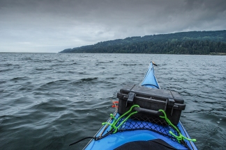
Paddling Out the First Night

The next morning I headed straight for the north end of the lagoon where it breeches and stayed there with the camera until I took a  lunch break.  The water was clear and almost flat; there was little wind.

DSC_0938

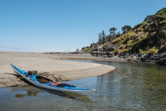
Lunch Stop at the Breech

Then I headed back towards the campground.  I bumped into Mark as he drifted his bait along the bottom;  he said he had gotten a couple of good strikes.
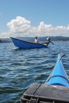
DSC_0943

Drift Fishing

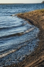
We chatted for awhile and then I went over to the spit and took a nap. Later in the day I poked along the eastern shore of the lagoon and walked the beach, looking at the rock formations and patterns in the sand.
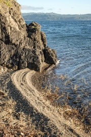
 

DSC_0960

A Mini Sand Spit

I discovered a Humboldt Gum plant, an endangered specie which I had seen before only on Humboldt Bay.  Other plants perched on the rocks, and many of them were blooming.
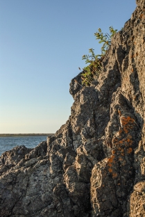
DSC_0959

Colors on the Rocks

By that time, the wind had kicked up sizeable wind waves out on the lagoon, and the sound of them on the beach was like music.  After a few more photos I paddled back to camp for dinner and a good night’s sleep.

DSC_0967

The next morning Charlotte picked me up and we went over the hill to Stone lagoon for the Explore North Coast hosted Rescue Practice Paddle.   Thanks, Mark and Charlotte, for a great weekend on Big Lagoon!

Mark Lufkin


Phil and Mark at Baker Beach on Labor Day

3 09 2014

Phil and I were eager to go camping in the kayaks before the summer ended, so I set one up for this last Labor Day weekend. I chose Baker Beach, just south of Trinidad.

Looking Toward Trinidad

Looking Toward Trinidad

We had plenty of company, because Steve Saunders and some family and friends joined us for the paddle out there. We scouted campsites from offshore and then decided on the very north end of the beach behind “the slot”. Our fully loaded boats slipped between small rocks as we landed easily on the narrow gravel beach. Steve and his friend, Ernie, had brought beer and chips, so we shared lunch with them before they departed for Trinidad.

Baker Beach Camp

Baker Beach Camp

Phil, then, went about devising his sleeping arrangements. With a tarp he had brought, a couple of sticks for poles, and a few feet of cord, he made himself a windbreak, shade, and a place to sleep. I waited to see the high tide line before deciding on a place to bed down.

Phil's Tarp Rigging

Phil’s Tarp Rigging

We passed the sunny but windy afternoon by reading, snoozing, gathering firewood, etc. Late in the afternoon we suited up again and took a short paddle up to the slot and out to Little Camel Rock. For dinner, I roasted a dozen oysters over a small fire and chased them with Tang. Phil had the ham sandwich he had skipped at lunch. Just before sundown it cooled off and the wind eased.

Sunset

Sunset

The sun set behind Trinidad Head and the water was flat. We both slept well. We woke about sunrise, although the sunlight had not touched the far horizon yet.

Making Coffee

Making Coffee

Phil made coffee before even getting out of his bivvy bag. I made a couple of cups between packing up my bedrolls. About the time we were ready to launch, Ed called on the VHF; he and Charlotte were coming out to see us! We met them just offshore and we all paddled down to Big Camel Rock. After loading up the kayaks on Phil’s new trailer and grabbing coffee at Murphy’s in Trinidad, we visited with Ed and Charlotte at the State Beach picnic tables. Thanks everybody, for being there with us!                   Mark


Klamath Estuary June 2013

2 07 2013

An unseasonal rainy spell affected the turnout for this mellow paddle but eight dedicated explorers showed up at the put-in at the mouth of the Klamath river. The water level was much lower than expected but the tide was on the rise.

Gathering at the put-in

Gathering at the put-in

We began by making our way up the first channel, poking through weeds and shallows as far as we could. Quite a few Osprey were screaming and flying overhead. Also lots of birdsong could be heard in the riparian area.

Heading up-channel

Heading up-channel

We retreated and headed up the next navigable arm.

Michael and Georgianna

Michael and Georgianna

Brent and Bruce

Brent and Bruce

By the time we’d explored this area the tide was up and we headed along the sandspit.

Heading up the next arm

Heading up the next arm

The mouth of the river had shifted from our last visit; the river now exiting in the middle of the spit.

Greg crossing the river mouth

Greg crossing the river mouth

The river flow was quite low so there was no issue of being swept out to sea. Rather, the ocean was sending water into the estuary and filling it up. We paddled across to the north end of the beach where the old mouth had been and landed for a picnic on the ocean side.

Landing at the location of the old mouth

Landing at the location of the old mouth

Picnic on the beach

Picnic on the beach

Probably an hour or so into lunch the rain began to come on in earnest so we packed up and headed back to the put-in to call it a day.

Jen heading back through the downpour

Jen heading back through the downpour

Take it home

Take it home

In spite of the weather another enjoyable adventure on a (for me) rarely visited stretch of water. Thank you to all who attended:Brent, Scott and Jen, Scott Harrison (who took the photos), Greg, Georgianna, and Bruce. The theme for this paddle was apparently “Funny Hats.” Georgianna and Bruce won.


North Of Trinidad to Whale’s Head

12 09 2012
Image

Mark sits with the boats before leaving for the paddle north.

Image

Nick stows gear at Indian beach.

With a week’s notice, Nick let me know that he wanted to paddle to and camp at Whale’s Head north of Trinidad.  He wanted to paddle out in the late afternoon, and I wasn’t sure I wanted to be on the water that close to sunset. We finally packed up and launched at Indian Beach at about 4:30pm on Saturday.

It was a sunny evening with medium swells and some wind and chop.  After rounding Trinidad Head we headed

Image

Nick and I paused for a photo-op off Elk Head.

Image

Nick and Mark off Megwil Point.

straight for Megwil Point north of College Cove to see what the waters looked like toward Whales Head.  The evening light was unique (we usually paddle in the morning) and it was different to see the coast sunlit from that side. We got as far as Green Rock before deciding to turn back and spend the night at College Cove.

Landing at the east end of College Cove was easy, once we timed the conditions at the beach.  The beach was wider there, and we found a couple of suitable tent sites.

Image

Image Nick (top) and Mark paddle through the foam toward the night’s camp.

While I set up my tent Nick shucked oysters and opened

Image

Kumamoto oysters and beer!

Image

I set up my tent.

a big bottle of beer.

Image

Sunset 7:30pm

It was a pretty evening with a great sunset.  We stayed up ’til 11 o’clock talking, enjoyed the clear, starry sky, and we hit the sack expecting fog and drizzle in the morning.

It stayed clear all night, and Sunday morning was clear as well!  I gathered wood for a small fire and Nick and I were having breakfast at about 7 o’clock.  Then we stuffed the gear, packed the boats, turned on the radios, and Nick checked to see if any ENC paddlers were within hailing distance.  Michael responded and he and half a dozen others met us off the cove.

Image

the “Sunday Services” group meets us soon after launch.


Image

From there, Nick and I paddled back north past Megwil Point and Green Rock and toward Whale’s Head.  The conditions were similar to the previous evening, with an early wind and chop.  It was great to paddle a new and different area and exciting to keep alert for new rocks and reefs.  Our chart didn’t name Whale’s Head so Nick pointed it out to me as we got there. We paddled in slowly toward the “beach” and looked for possible landings, and, despite the swells, got well inside the cove formed by the Head.  In the half hour we spent in the moderate protection of Whale’s Head, we didn’t see any possible tent sites, and only 2 so-so landing sites.  I suppose that if we had been with a larger group, we might have landed then, but we were being cautious, so we didn’t.

Image
ImageWe headed back through various rocks toward Trinidad with the wind from behind helping us along.  We got hot from the sunshine, so near Green rock we rolled to cool off.  Nick suggested we go around Flatiron Rock, so we paddled into the sun and stopped to check out the cove there.  Then it was back toward The Head past a couple of kayak fisherman, and in to Indian beach.  The whole morning was a fun paddle, with moderate conditions and sunny skies.  This whole trip was fun, with plenty of time to enjoy the water, weather, beaches and each other’s company.ImageImageMark Lufkin


To White Slough on Labor Day

6 09 2012

Image

One tern per piling seems to be the rule at this burned out dock.

Image

Greg keeps up with the current on his way south.

I paddled to a couple of new campsites this gorgeous Labor Day weekend.  I launched from the C Street dock on the Eureka waterfront late Saturday morning and fought the tide south on the way to King Salmon.  I topped only to take a few photos on the way.  I came upon Greg from Pacific Outfitters going the same way near Fairhaven.  He was just holding his own against the current with the pedals and sail on his Hobie.  He passed me once the wind picked up and while I was making photos.


Image


The weathered remains of the trees on the beach made an interesting sight.

Image

The old Humboldt Bay Yacht Club sparkles in the sun.

I headed straight for King Salmon from there and crossed the wide part of the bay in front of the Bar. 

Image

I chose the end of the beach furthest from the houses.

It took about an hour to cross to the beach at King Salmon, where I found as many dogs as people.  I checked out possible camp sites and decided on the beach inside the breakwaters.   I had coffee and waited for evening.  The dogs on the beach got interested when I was cooking dinner and a few people asked about the kayak.  I had a good view of the Bar from my beach and the sport and commercial boats coming and going. 

Image

A long exposure and resting the camera on the boat captures the glow of the city and lights up the beach.

The last few beachgoers left a little after sunset and no one bothered me that night; I slept well, waking up just to see the big moon and the lights of Eureka.


Image

I waited for the tide to rise so I could keep paddling!

I took my time about getting on the water the next morning because the tide was low and would be going my way for hours.  In an hour I was deep in the mudflats of southbay and waiting for the tide to rise so I could keep going!   It took an other hour, but finally I was able to paddle into the main channel of White Slough and my next night’s camp.  Again, I checked the whole area at the end of the slough for the best site and decided on the flat top of a dike overlooking the place that the Jupiter used to rest in the mud.


Image

I look over the site of the old dredge- Jupiter- that made the dikes all over the bay and finally rested in the mud ’til it burned to the waterline.

I had the whole day ahead of me, so I took photos, relaxed, talked to myself, took more photos, made coffee, ate lunch, etc.    It was good that I didn’t camp in the woods below the dike, because it was currently home to a bear.  That made me a little wakeful that night, but the only disturbance I had was from a possum coming down the dike.

Image

Crossing the Bay again was foggy this time.

To make the tide this time I got up at 5 o’clock.  After coffee,and granola/yogurt, I headed back at 6:30 and was at King Salmon at low tide- just in time to get the current back to the Eureka waterfront.  I reached the C Street dock at 10 o’clock and had the whole rest of the day to dry and put the gear away.


Mark


Klamath Estuary July 2012

23 07 2012

Twelve inquisitive paddlers gathered at the Klamath estuary sunday morning and be 10:15 we were on the water and ready to explore.

Low water but still an easy launch

An adult bald eagle was perched in a snag across the way warily observing the operation. All boats launched, we make our way up the first channel nearest the frontage road. Kingfishers, cormorants, mallards, and osprey abound and we are surprised by a sighting of a beaver swimming non-chalantly across the channel. We follow successive sloughs up to dead-ends. The water level is low due to a minus tide but beginning to rise. After the beaver sighting we become aware of many large tunnels into the island banks.

We’re on our way. The blob in the snag is an adult bald eagle.

The eagle is unperturbed as we paddle by directly underneath its perch. The estuary is beginning to fill up by noon so we head to the spit to take a break and have some refreshment. A line of blue sits out over the ocean and we will it our way but the day remains overcast.

Lunch on the beach

As scheduled, during lunch break a grey whale meandered by in front of us. A huge flock of elegant terns were roosting on the spit and occassionally would rise up in a raucous mass. After lunch we were all pretty relaxed and lazy. We continued up the main part of the river for a ways but didn’t travel very far. It had been a good day and a relaxing paddle and we headed back to the put-in for beer, peanuts, and farewells.


Nick and Mark’s Great Adventure

28 05 2012

Nick told me about a nice kayak campsite he had found on Mad River Slough, so on the 2nd weekend of this month (May) this year (2012) our plans for that came together.  I paddled from the C St. dock on the Eureka waterfront at about 11 o’clock Saturday morning, and got to MR Slough in the middle of the afternoon.Image  The tide was still pretty low there. NImageick launched at the Arcata Marsh  at 6 o’clock when the tide had gotten high enough to paddle across the mud flats at the top of Humboldt Bay. He paddled into the evening sun for about an hour and met me at the Ma-l’el Dunes Parking lot.  From there Imagewe paddled together awhile up the slough and he showed me his spot.  It was a beautiful little meadow above the slough a few feet and nestled in the trees.  We tied the boats up on a little beach just made for kayaks and carried our gear up to the meadow, set up the tents and prepared dinner.ImageImage  Nick shucked oysters for us and I made pasta, which we shared while enjoying the sunset view of the Arcata Bottoms.  It was graduation weekend for HSU, and we could hear the Marching Lumberjacks from somewhere in Arcata. Image We talked for a couple of hours in the dark, enjoyed his growler of good beer, then hit the sack.  In the morning we took our time about launching for the paddle home.  By the time we paddled put to the Bay we had a little trouble finding the channel south towards Eureka.  It was good to have Nick’s company for the trip back.  ImageThe tide helped us back down the MR Slough Channel (a mile from shore), and we got to the dock in in Eureka in about 3 hours. Nick called for his ride back to Mckinleyville and I wheeled my boat the 3 blocks back to my place.  This was just my first camp out of the Spring, and it was terriffic!  Thanks Nick!Image 

Mark


Sea Kayaking the Redwood Coast

17 02 2012

Explore North Coast is very excited about releasing a sea kayaking paddle guide for north coastal California. In the making for more than three years, Sea Kayaking the Redwood Coast is an insider’s guide to the most popular kayaking areas in this region. Written by club members who love paddling the North Coast, the full color guide describes thirty-five routes in nineteen locales, from the mouth of the Eel River to the spectacular coastal areas of Crescent City. It provides directions to launch areas, descriptions of routes, facilities and potential hazards. Detailed maps show launch locations and facilities, along with prominent landmarks needed to safely explore the region. Sidebars describe the rich cultural history and the abundant wildlife of the North Coast. The paddle guide can be purchased directly from ENC’s website at http://www.explorenorthcoast.net/

Greg Bundros


Some of Our Favorite Places

9 02 2012

There are many incredible sea kayaking opportunities in Humboldt and Del Norte Counties. The purpose of this post is to provide maps of a few of our favorite spots, primarily for those who might be visiting our area from faraway places. For a complete list and description of paddling opportunities and launch points along this incredible coast, check out Sea Kayaking the Redwood Coast, a sea kayaking paddle guide written by members of Explore North Coast. It can be purchased from our website at http://www.explorenorthcoast.net/.

Crescent City

Crescent City has many great paddling opportunities. Our favorite launches are from Pebble Beach, just south of Pt. St. George, and South Beach and Whaler Island on the south side of town.

Pebble Beach Launch Area

Anchor Way at South Beach

False Klamath Cove – Wilson Creek

This is a very exposed section of coastline that requires exceptional conditions to paddle safely.  The launch point is from the NORTH end of the cove, about 6.3 miles north of the town of Klamath.

False Klamath Cover at Wilson Creek

Humboldt Lagoons

There are a series of breathtaking coastal lagoons in Humboldt County. Our favorites are Big Lagoon and Stone Lagoon. At Big Lagoon, the launch is from the Big Lagoon County Park, located about seven miles north of Trinidad on the west side of Hwy. 101. Turn west onto Big Lagoon County Park Road and follow the signs to the day use area. Stone Lagoon is about six miles further north. At Stone Lagoon, we generally launch from the Visitor Center at mile marker 108.5 on Hwy. 101.

Big Lagoon and Stone Lagoon

Trinidad

This paddle is one of the premier paddle locations along the north coast. Launch points include State Beach, if conditions allow, or Indian Beach.

Take the Trinidad exit (exit 728) off Hwy. 101. Turn west. Follow the road past the Chevron station and market. Follow the road as it swings left at Trinidad Elementary School and then right at the Memorial lighthouse and down to Trinidad State Beach and the sandy parking lot. To the left is the paved lot for the Seascape Restaurant. The Indian Beach launch site is at the far end of the paved lot. After unloading your boat and gear, please park your vehicle in the sandy parking lot by Trinidad State Beach so the parking for Seascape Restaurant customers is not impacted.

Trinidad Launches

Mad River Slough

Mad River Slough is part of the Humboldt Bay National Wildlife Refuge and a fascinating place to paddle. From Arcata and the Arcata/Samoa Blvd. exit (exit 713) from Hwy. 101, head west on Samoa Blvd. (Hwy. 255) for 3.7 miles. Cross over the Mad River Slough Bridge and park on the right side of the road. From Eureka, head west on Hwy. 255 across the Samoa Bride to the stop sign at Samoa Boulevard/New Navy Base Rd. Turn right and travel about 3.1 miles. Do not block the driveway of the lumber mill. A gravel ramp leads to the water.

Mad River Slough Launch

Samoa Boat Ramp County Park

This paddle takes advantage of breaking waves that form by rip currents flowing across shallow sand bars in Humboldt Bay. Take Hwy. 101 as it passes through Eureka to Hwy. 255. Go west across the Samoa Bridge to the stop sign at Samoa Boulevard/New Navy Base Rd. Turn left and proceed approximately five miles to Samoa Boat Ramp County Park on the left.

Samoa Boat Ramp County Park

If you’re planning to visit and paddle in our area, feel free to drop us a line through our club’s website. We spend a lot of time on the water and might be able to accompany you to some of our favorite areas.

Read on to get a feel for some of the paddling opportunities.

Enjoy!

Greg Bundros


Once Around Arcata Bay

1 12 2011

With the cold and rain coming to Humboldt this October, I figured that my kayak camping was over for the season. But, this Thanksgiving, the forecast looked great, and so did the tides! So, I planned on a for day/three night trip to Mad river Slough and back to Eureka. My stash of provisions allowed me to get ready in just a half day.

After a turkey dinner at the Silvercrest Salvation Army Residence with Patti, I loaded the boat and she saw me off at the C Street dock in the rain.

Day 1: Thursday. Showers. Paddled across the inner reach of the Eureka channel to Indian Island. Set up camp an hour before sunset and slept well, though it rained off and on all night.

Day 2: Friday. Partly cloudy and no wind. Paddled 5.5 miles to “Humgum Island”(thanks Barry) near the top of Mad River Slough. The very high tide (8.6) had to subside before I could set up the tent. Thick fog came in that night and , with no moon, visibility was nil.

Day 3: Saturday. Thick fog. Paddled an hour down the slough towards the Mal’el Dunes parking lot. Spent 10 minutes wondering if I’d made a wrong turn in the fog. Called Charlotte on a stranger’s cell phone and had a cup of coffee. Paddled out of the slough and across the top of Arcata Bay by the compass and over to the Arcata Marsh. Met Charlotte and had lunch and Larry and Peggy showed up and so did John and Marcella. At high tide I headed for Sand Island to camp. Passed the ruins on the way.Just before I got to Sand Island I was waved off by a warning shot and a yell by a duck hunter, so I turned and paddled toward Bracut. Finished a 10 mile day by camping there. Watched a hunter bag a duck right in front of my camp before dinner.

Day 4: Sunday. Cloudy, no wind. I waited on the incoming tide to give me enough water over the mudflats to paddle the 4 miles back to Eureka. Arrived at C Street at about 11:00 and wheeled my boat back home. I spent the rest of the day drying out my gear and relaxing.

Mark Lufkin